

Drone Services
See the Whole Job. Before It Becomes a Problem.
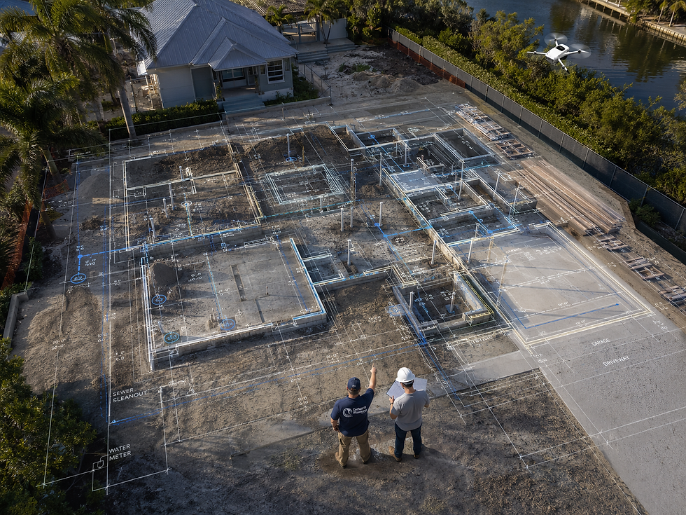
Carhart Plumbing's drone mapping and plan overlay service captures current aerial imagery of your jobsite and overlays your architectural, civil, and construction plans directly onto the site — giving your project team real-time visual coordination that catches conflicts, confirms layouts, and keeps the job moving before small discrepancies become expensive problems.
Drone Mapping & Plan Overlays — Real-Time Aerial Intelligence for South Florida Construction Projects
Construction projects fail in the gap between what the plans show and what's actually happening on the ground. A utility line in the wrong location, a foundation poured six inches off layout, a plumbing rough-in that conflicts with a structural element that wasn't fully coordinated — these are the kinds of field conditions that generate change orders, delay inspections, and drive up project costs in ways that are almost entirely preventable. The problem isn't the plans. The problem is that nobody had a clear, current picture of the site when it mattered most.
Carhart Plumbing now offers professional drone mapping and plan overlay services that close that gap. We fly current aerial imagery of your jobsite and overlay your architectural, civil, MEP, and construction documents directly onto the captured site data — giving your project team a precise, georeferenced view of what's been built, what's been roughed in, and what's planned — all in the same frame. It's a tool that general contractors, developers, engineers, and owners have needed for decades. The technology is now here, and Carhart Plumbing is putting it to work on South Florida projects.
This service was developed directly out of our experience managing complex plumbing scopes on commercial, industrial, and civil projects across Palm Beach, Martin, and St. Lucie Counties. We know what field coordination breakdowns look like from the inside — missed utility conflicts, underground plumbing that doesn't line up with architectural walls, grading conditions that affect drainage design, slabs that go in before the rough-in gets verified. Our drone mapping program was built to address exactly these failure points, because we've lived them on job sites for over two decades.
What We Capture and Overlay
Our drone flights produce high-resolution, georeferenced aerial imagery that is then processed and aligned with your project documents. Plan overlays can be applied at any project phase — pre-construction, during active construction, and for progress documentation and punch list verification.
Building and Wall Layouts — Verify that structural and architectural elements are being built precisely where the plans call for them. Catch setback issues, alignment discrepancies, and layout errors before concrete is poured or framing is complete.
Underground Plumbing and Utilities — Overlay your utility plans against current site conditions to confirm that underground plumbing, electrical conduit, storm drainage, and other buried infrastructure is installed in the correct location before it's covered. This is the single highest-value application of plan overlay technology for plumbing contractors and civil engineers.
Landscaping and Hardscaping Locations — Coordinate landscape and hardscape placement against civil grading plans, drainage design, and underground utility routes — preventing the conflicts that show up when irrigation gets installed over a sewer lateral or a paver contractor cuts into a water main.
Foundations, Slabs, and Structural Elements — Confirm that foundation footprints, slab edges, and structural pours align with design documents before the next phase begins. Post-pour corrections are among the most expensive change orders on any project.
Site Access, Grading, and Project Progress — Document grading conditions, access routes, staging areas, and construction progress at any point in the project schedule. Provide owners, lenders, and inspection authorities with accurate, timestamped aerial documentation that reflects actual field conditions.
Potential Conflicts Between Plans and Actual Field Conditions — The most valuable function of plan overlay is what it reveals before it becomes a problem. When an overlay shows a conflict between what was designed and what was built, you have the opportunity to resolve it at the planning table rather than with an excavator after the fact.
Our team processes captured imagery quickly and delivers overlays in formats compatible with your project management platforms, design software, and on-site review workflows. We work directly with your GC, project manager, MEP engineers, and design team to make sure the data is actionable from the moment it lands.

Why Choose Us
Built by contractors, for contractors — Our drone mapping program was developed by a team with over 75 years of combined plumbing, civil, and construction experience. We understand what field coordination failure looks like and designed this service specifically to prevent it.
We know what to look for — A drone operator without construction knowledge captures imagery. We capture imagery and interpret what it means for your project — because we've managed the scopes, read the plans, and walked the same coordination failures that this service is designed to prevent.
Deep South Florida construction experience — Nick Carhart has spent over three decades on South Florida job sites — residential, commercial, industrial, and civil. We understand the region's soil conditions, water table challenges, permitting environment, and the specific coordination demands of building in Palm Beach, Martin, and St. Lucie Counties.
Integrated with your plumbing scope — When Carhart Plumbing is managing your plumbing construction scope, drone mapping is a natural extension of the same oversight — not a separate vendor relationship to manage. One team. One point of contact. Full site coordination from underground rough-in to aerial verification.
Fast turnaround on deliverables — We process and deliver overlays quickly enough to be actionable within your project schedule — not days after the window to correct a problem has already closed.
Compatible with your existing platforms — We deliver imagery and overlays in formats that work with your project management software, design platforms, and on-site review workflows. No new systems to learn.
Objective documentation you can stand behind — Timestamped, georeferenced aerial imagery is defensible documentation — for draw approvals, inspection authorities, owner reporting, and dispute resolution.
Licensed, insured, and accountable — CFC-1426407. The same standard of accountability we bring to every plumbing scope extends to every service we offer. We stand behind our work.
Services Challenges
The coordination failures that cost South Florida construction projects time and money — and how aerial plan overlay prevents them.
Field coordination breakdowns are the leading driver of change orders, schedule delays, and budget overruns on construction projects. Most of them share a common root cause: no one had a current, accurate picture of what was actually happening on the site when a decision needed to be made. Drone mapping and plan overlay directly addresses that problem.
Underground utility conflicts discovered after burial — One of the most costly and disruptive events on any construction project is discovering that buried utilities — plumbing, electrical, storm drainage — don't align with where the plans said they'd be, after they've already been covered. Aerial overlay of utility plans against current site imagery catches these conflicts before backfill, not after.
Foundation and slab pours that don't match design documents — A foundation poured out of position creates cascading problems for every system that follows — structural framing, MEP rough-in, exterior envelope, and final layout. Plan overlay provides a georeferenced verification checkpoint before the pour and confirms alignment immediately after.
No accurate record of as-built underground conditions — When a project closes out, the as-built record of what's underground is often incomplete, inaccurate, or missing entirely. Drone imagery captured at each phase of underground installation creates a documented, georeferenced record of what was installed and where — invaluable for future maintenance, renovation, and emergency response.
Trade coordination failures between GC, MEP, and civil scopes — When architectural, civil, and MEP plans aren't fully coordinated in the field, conflicts show up as physical collisions between systems that were designed in separate documents. Plan overlays bring all of those documents into a single current site view, making coordination conflicts visible before they become field problems.
Owner and lender progress documentation gaps — Owners, lenders, and inspection authorities increasingly require accurate, timestamped progress documentation as a condition of draw approvals and milestone certifications. Drone imagery provides defensible, professional documentation at every project phase without interrupting the construction schedule.
Grading and drainage conditions that affect plumbing system design — In South Florida's flat terrain with high water tables and seasonal flooding, site grading has a direct impact on how storm drainage, sewer laterals, and perimeter drainage systems perform. Aerial imagery of existing and installed grading conditions allows engineers and contractors to verify performance against design intent before problems develop.
Schedule and progress disputes between owner and contractor — When disputes arise about what was completed and when, photographic and aerial documentation becomes critical evidence. Drone imagery with timestamped georeferencing provides an objective record that protects all parties and resolves disputes without litigation.
Our Process
01
Project Planning
Every successful plumbing project starts with a clear plan. At Carhart Plumbing, we take a structured approach to every job, helping ensure quality workmanship, efficient scheduling and installation.
02
Value Engineering
We evaluate materials, installation methods, to identify the most efficient plumbing solution. Our goal is to help reduce waste, avoid unnecessary expenses, and deliver dependable results.
03
Project Execution
Once the plan is set, our team gets to work. We manage the plumbing scope with quality, safety, and clear communication—keeping the jobsite organized and the project moving from start to finish.
04
Project Delivery
We perform final inspections, quality checks, and system reviews to make sure the plumbing work is finished correctly. Our goal is to deliver durable results that perform long term and leave every customer confident in the work completed.

Testimonials
What Our Clients Say About Working With Us
From initial planning to final delivery, our clients value our commitment to quality, communication, and reliable project execution.


Your Next Plumbing
Project Starts Here
From everyday repairs to water heaters, backflows, remodel plumbing, and ongoing maintenance, Carhart Plumbing makes it simple to get the job done right. We show up prepared, communicate clearly, and deliver dependable plumbing solutions for homes and businesses throughout South Florida.
Schedule Service Today
Fast response. Honest work. Professional results.